


TECHNOLOGICAL WAY TO PROTECT OUR LANDS: AIRCRAFT AID AGRICULTURE AND DISASTER MANAGEMENT
Mediterranean area is a rich field with very fertile lands and beautiful forests. However, we are experiencing many losses in our forest and agricultural areas due to both climate change and human errors. These losses are sometimes caused by fire, erosion, etc. sometimes with natural disasters and sometimes with insufficient greening. In order to solve this problem, both a technical and social innovation application and a visionary breakthrough was initiated by R&D studies of Dr. Yaşam AYAVEFE.
Many countries around the world use aircraft to solve this problem. With the development of drone technology, drone-based applications appear in many areas. One of these areas is applications for agriculture, and the use of drones in this area is becoming widespread day by day. Unmanned aerial vehicles are reusable, unmanned aerial vehicles that have their own power system, carry deadly and non-lethal payloads, and are flown automatically or with a remote-control system. These vehicles are divided into two classes: the first is drones that fly by remote control, and the second is aircraft that can move automatically over a certain flight plan (Kip, 2013). Low and medium resolution aerial photographs have been used in erosion studies since ancient times. However, high-resolution sequential aerial photographs are required to measure and analyze the temporal variation of the gully. Using high-resolution digital elevation models produced from these photographs, the locations of the gullies can be determined and their volumes can be calculated successfully (Nachtergaele & Poesen, 1999). Recently, high resolution digital elevation models have been produced using aerial and terrestrial scanners, but the high cost of these technologies limits their use (Marzolff & Poesen, 2009).

On the other hand, many targets such as agricultural spraying, fire extinguishing, and erosion-preventing greening can be realized thanks to drones. (Pharne et al. 2018) developed a drone-integrated spray system to spray pesticides on agricultural products in their study. In this study, in which Arduino programming language is used, it is aimed to control harmful organisms or to minimize their damage with pesticides in the pesticide warehouse integrated with the drone. With the help of nozzles connected to the spraying storage system, the spraying process is carried out on the crop fields. It is stated that an equal pressure will be applied to the spraying tank to prevent pesticide waste, and therefore the pesticide will be sprayed correctly on the crops. (Suryawanshi et al. 2019) carried out a study that enables the spraying of the agricultural field by integrating a 1000 ml capacity spraying tank into the remotely controlled quadcopter. In this study, the chemical spraying process was provided by using two nozzles, corresponding to the two opposite ends.

(Spoorthi et al. 2017) mentions the drone work that sprays pesticides equally all over the agricultural area in their study. This system, which can be controlled remotely with an Android application, can be fully guided remotely using the Global Positioning System (GPS), regardless of the shape of the agricultural area. It has been stated that the spraying of agricultural areas using the drone spraying system is quite easy compared to other methods.
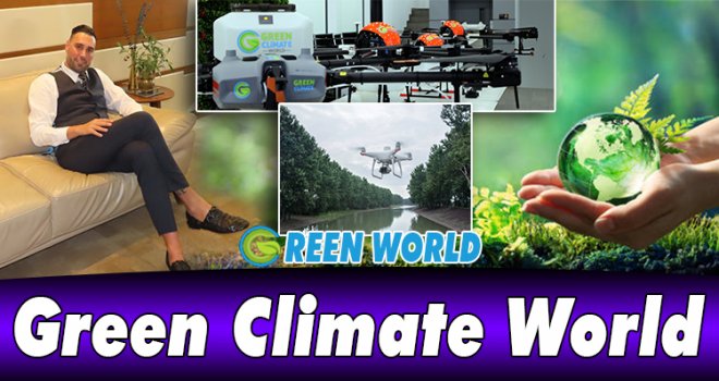
Dr. Yaşam AYAVEFE, on the other hand, has started to research how these structures, called spraying drones, can be used environmentally friendly, instead of an application that cannot be considered completely environmentally friendly, such as the use of pesticides. After years of work, he has developed suitable tools and techniques for greening and fire protection works. Dr. AYAVEFE and its expert team argued that the use of unmanned aerial vehicles in agriculture can increase productivity in agricultural lands by remote sensing. Unmanned aerial vehicles can perform analysis more quickly and economically than classical methods in examining the condition of plants, disease detection and weed detection in the field of agriculture. These tools can also be used in the fields of spraying, harvesting, mapping and imaging.
(Long et al. 2018) talk about the use and importance of artificial intelligence in agricultural areas in their study. They argued that our country is among the economically leading sectors in the agricultural sector. For this reason, the use of artificial intelligence technology in agricultural lands, compared to classical methods, provides better results and increases productivity on the product/harvest. They cited the use of autonomous tractors, drones and machine vision systems as examples of the use of artificial intelligence technology in the field of agriculture. With the use of artificial intelligence for spraying, more controlled systems can be obtained.
Dr.YAŞAM AYAVEFE

REFERENCES
Kip, Z. (2013). İha Görüntülerinin Anlamlandırılması Üzerine Bir Sistem Analizi Çalışması. Beykent Üniversitesi, Fen Bilimleri Enstitüsü, Bilgisayar Mühendisliği Anabilim Dalı.
Nachtergaele, J., & Poesen, J. (1999). Assessment of soil losses by ephemeral gully erosion using high-altitude (stereo) aerial photographs. Earth Surface Processes and Landforms, 24(8), 693–706.
Marzolff, I., & Poesen, J. (2009). The potential of 3D gully monitoring with GIS using highresolution aerial photography and a digital photogrammetry system. . Geomorphology(111), 48-60.
Pharne I D, Kanase S, Patwegar S, Patil P, Por, A, Kadam Y, 2018, Agriculture Drone Sprayer, International Journal of Recent Trends in Engineering & Research (IJRTER), 4, 181–185.
Spoorthi S, Shadaksharapp, B, Suraj S, Manasa V K, 2017, Freyr drone: Pesticide/fertilizers spraying drone-an agricultural approach, In 2017 2nd International Conference on Computing and Communications Technologies (ICCCT), 23–24 February, Chennai, India, 252–255.
Suryawanshi V K, Ashok J, Rajmane S A, Mali S S, 2019, Design & Development of Agricultural Fertilizer Spraying Drone with Remote Controller and Autonomous Control with low weight Aluminium Alloy frame Structure, J. Remote Sens. GIS Techno., 5, 1–8.
Long X, Deng K, Wang G, Zhang Y, Dang Q, Gao Y, vd., 2020, PP-YOLO: An Effective and Efficient Implementation of Object Detector, arXiv preprint arXiv:2007.12099, https://doi.org/10.48550/arXiv.2007.12099.


-
 Bayındırlık ve Ulaştırma Bakanı Erhan Arıklı'nın 1 Mayıs İşçi Bayramı mesajı yay..
-
 13 kilo uyuşturucusu valizle getirdi
-
 Güney'de et ve zeytinyağı fiyatlarında artış
-
 HTKS, 4 Mayıs’tan sonra Ercan’da yeniden grev başlatacağını açıkladı
-
 Mağusa'daki altı plaj 15 Mayıs itibarıyla hizmet vermeye başlıyor
-
 Tatar: Devletimizden, egemenliğimizden ve Türkiye’nin garantörlüğünden asla vazg..
-
 Ataoğlu: Coğrafi Bilgi Sistemi’nin kurulması için çalışmalar başladı